
Berkas:ECDM 20240123 China earthquake and landslide.pdf
Ukuran pratayang JPG ini dari berkas PDF ini: 800 × 554 piksel Resolusi lainnya: 320 × 222 piksel | 640 × 443 piksel | 1.024 × 709 piksel | 1.280 × 886 piksel | 1.625 × 1.125 piksel.
Ukuran asli (1.625 × 1.125 piksel, ukuran berkas: 726 KB, tipe MIME: application/pdf)
Ringkasan
| Deskripsi |
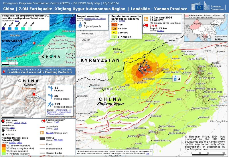
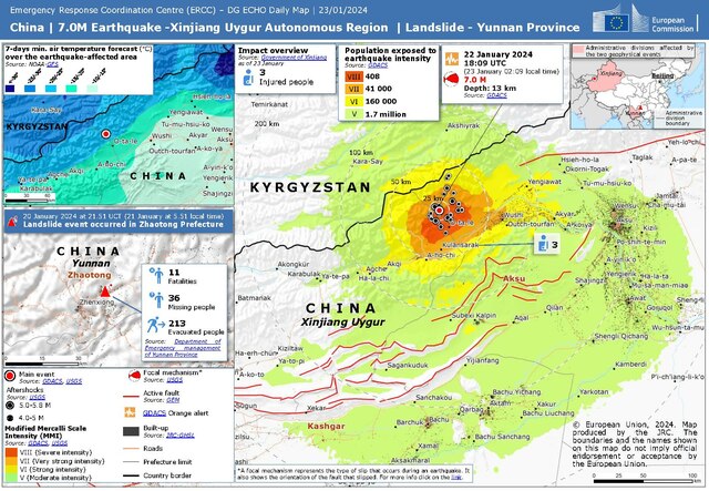
English: China | 7.0M Earthquake - Xianjiang Uygur Autonomous Region | Landslide - Yunnan Province ECHO Daily Map of 23 January 2024 |
| Tanggal | |
| Sumber | https://erccportal.jrc.ec.europa.eu/ECHO-Products/Maps#/maps/4765 |
| Pembuat | Emergency Response Coordination Centre with Sources: GDACS, USGS, GEM, JRC GHSL, Government of Xinjiang, Department of Emergency management of Yunnan Province, NOAA GFS |
Lisensi
Public documents (any content whatever its medium) produced by the Commission or by entities on its behalf published by the Commission or the Publications Office or which have not been published for economic or other practical reasons, such as studies, reports and other data shall be made available for reuse unless otherwise specified[1] without restrictions according to 2011/833/EU: Commission Decision of 12 December 2011 on the reuse of Commission documents
Note: Content on ec.europa.eu or its data portal is published with the specified restrictions of the CC BY 4.0 license.
| |
Riwayat berkas
Klik pada tanggal/waktu untuk melihat berkas ini pada saat tersebut.
| Tanggal/Waktu | Miniatur | Dimensi | Pengguna | Komentar | |
|---|---|---|---|---|---|
| terkini | 3 April 2024 21.40 |  | 1.625 × 1.125 (726 KB) | Don-vip | new version with fixed typo Xianjiang => Xinjiang |
| 23 Januari 2024 22.55 |  | 1.625 × 1.125 (726 KB) | Lupe | Uploaded a work by Emergency Response Coordination Centre with Sources: GDACS, USGS, GEM, JRC GHSL, Government of Xinjiang, Department of Emergency management of Yunnan Province, NOAA GFS from https://erccportal.jrc.ec.europa.eu/ECHO-Products/Maps#/maps/4765 with UploadWizard |
Penggunaan berkas
Halaman berikut menggunakan berkas ini:
Penggunaan berkas global
Wiki lain berikut menggunakan berkas ini:
- Penggunaan pada en.wikipedia.org
- Penggunaan pada zh.wikipedia.org