
Berkas:The Arsenic Labyrinth at Botallack Mine - geograph.org.uk - 490315.jpg
Tak tersedia resolusi yang lebih tinggi.
The_Arsenic_Labyrinth_at_Botallack_Mine_-_geograph.org.uk_-_490315.jpg (640 × 458 piksel, ukuran berkas: 61 KB, tipe MIME: image/jpeg)
Ringkasan
| Deskripsi |
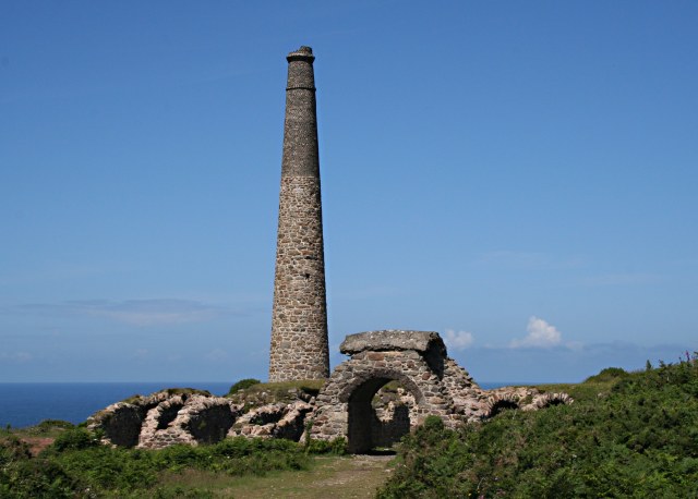
English: The Arsenic Labyrinth at Botallack Mine Arsenic compounds were an unwanted pollutant in tin ore which ruined the smelting process. The solution was to heat the ore to drive off the arsenic as a vapour. In the early days of mining this badly polluted the surrounding countryside. However arsenic itself proved to be a saleable by-product so the arsenic fumes were sent through a labyrinth of tunnels where it would condense on the tunnel walls. This photo shows part of the arsenic labyrinth at Botallack mine. The maze of tunnels has partially collapsed. Half way through the labyrinth, the tunnel passes over the top of an arch to cross one of the entrances to the mine. At the end of the labyrinth the remaining fumes passed up the tall chimney shown in the photograph. |
| Tanggal | |
| Sumber | From geograph.org.uk |
| Pembuat | Tony Atkin |
| Atribusi (required by the license) | Tony Atkin / The Arsenic Labyrinth at Botallack Mine / |
| Lokasi kamera | | Lihat gambar ini dan gambar di sekitarnya di: OpenStreetMap |
|---|
_heading:292.00&language=id)
| Lokasi objek | | Lihat gambar ini dan gambar di sekitarnya di: OpenStreetMap |
|---|
_heading:292.00&language=id)
Lisensi

|
This image was taken from the Geograph project collection. See this photograph's page on the Geograph website for the photographer's contact details. The copyright on this image is owned by Tony Atkin and is licensed for reuse under the Creative Commons Attribution-ShareAlike 2.0 license.
|
Berkas ini dilisensikan di bawah lisensi Creative Commons Atribusi-Berbagi Serupa 2.0 Generik
Atribusi: Tony Atkin
- Anda diizinkan:
- untuk berbagi – untuk menyalin, mendistribusikan dan memindahkan karya ini
- untuk menggubah – untuk mengadaptasi karya ini
- Berdasarkan ketentuan berikut:
- atribusi – Anda harus mencantumkan atribusi yang sesuai, memberikan pranala ke lisensi, dan memberi tahu bila ada perubahan. Anda dapat melakukannya melalui cara yang Anda inginkan, namun tidak menyatakan bahwa pemberi lisensi mendukung Anda atau penggunaan Anda.
- berbagi serupa – Apabila Anda menggubah, mengubah, atau membuat turunan dari materi ini, Anda harus menyebarluaskan kontribusi Anda di bawah lisensi yang sama seperti lisensi pada materi asli.
Riwayat berkas
Klik pada tanggal/waktu untuk melihat berkas ini pada saat tersebut.
| Tanggal/Waktu | Miniatur | Dimensi | Pengguna | Komentar | |
|---|---|---|---|---|---|
| terkini | 5 Februari 2011 06.15 | | 640 × 458 (61 KB) | GeographBot | == {{int:filedesc}} == {{Information |description={{en|1=The Arsenic Labyrinth at Botallack Mine Arsenic compounds were an unwanted pollutant in tin ore which ruined the smelting process. The solution was to heat the ore to drive off the arsenic as a vap |
Penggunaan berkas
Halaman berikut menggunakan berkas ini:
Penggunaan berkas global
Wiki lain berikut menggunakan berkas ini:
- Penggunaan pada bg.wikipedia.org
- Penggunaan pada en.wikipedia.org
- Penggunaan pada ko.wikipedia.org
- Penggunaan pada kw.wikipedia.org
- Penggunaan pada mk.wikipedia.org