Berkas:Maurya Empire, c.250 BCE 2.png

Konten halaman tidak didukung dalam bahasa lain.
Dari Wikipedia bahasa Indonesia, ensiklopedia bebas

Ukuran asli(1.200 × 1.121 piksel, ukuran berkas: 2,26 MB, tipe MIME: image/png)

Berkas ini berasal dari Wikimedia Commons dan mungkin digunakan oleh proyek-proyek lain. Deskripsi dari halaman deskripsinya ditunjukkan di bawah ini.

Ringkasan

Deskripsi
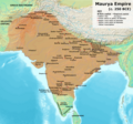
English: Note: This was the standard "textbook" map of the Maurya Empire. Historians are now arguing that the Maurya Empire did not include large parts of India, which were controlled by autonomous tribes. For such a map, see File:Maurya Empire, c.250 BCE.png.
Alternative map of Maurya Empire

Boundaries are based on Charles Joppen Historical Atlas of India (1907), see File:India_in_250_B._C.jpg.

Other Sources:

Other sources:

  • Grainger, John D. (1990, 2014). Seleukos Nikator: Constructing a Hellenistic Kingdom. Routledge.
  • Keay, John (2000). India, a History. New York: Harper Collins Publishers.
  • Kulke, H.; Rothermund, D. (2004). A History of India, 4th, Routledge.
  • Puri, Baji Nath (1996). Buddhism in Central Asia. Delhi: Motilal Banarsidass.
  • Raychaudhuri, H. C.; Mukherjee, B. N. (1996). Political History of Ancient India: From the Accession of Parikshit to the Extinction of the Gupta Dynasty. Oxford University Press.
  • Stein, Burton (1998). A History of India (1st ed.), Oxford: Wiley-Blackwell.

Notes:

  • Sri Lanka and the southernmost parts of India (modern Tamil Nadu and Kerala) remained independent, despite the diplomacy and cultural influence of their larger neighbor to the north (Schwartzberg 1992, p. 18; Kulke & Rothermund 2004, p. 68).
  • The account of Strabo indicates that the western-most territory of the empire extended from the southeastern Hindu Kush, through the region of Kandahar, to coastal Baluchistan south of that (Raychaudhuri & Mukherjee 1996, p. 594).
  • The claim that Aria/Herat was one of the provinces (alongside Arachosia, Gedrosia, and Paropamisadae) ceded by Seleucus to Chandragupta Maurya is often repeated, but Aria (modern Herat) "has been wrongly included in the list of ceded satrapies by some scholars [...] on the basis of wrong assessments of the passage of Strabo [...] and a statement by Pliny." (Raychaudhuri & Mukherjee 1996, p. 594). Seleucus "must [...] have held Aria", and furthermore, his "son Antiochos was active there fifteen years later." (Grainger 2014, p. 109).
  • "The region of Aria is definitely known to have been Seleucid under Seleucus I and Antiochus I as it definitely was after Antiochus III's great campaign in the east against the Parthians and Bactrians. [...] There is no evidence whatever that it did not remain Seleucid, like Drangiana, with which it is linked by easy routes." -Susan M. Sherwin-White and Amélie Kuhrt (1993) From Samarkhand to Sardis: A New Approach to the Seleucid Empire, University of California Press, pp.79-80.
  • It is recorded that Drangiana province continued to be in the Seleucids' hands, as per [1].
  • "Desert of Gedrosia [...] was left an unclaimed wilderness." —Kosmin, Paul J. (2014), The Land of the Elephant Kings Space, Territory, and Ideology in the Seleucid Empire, Harvard University Press, p.16
  • Schwartzberg (p. 18) speculates about the Buddhist culture and Kharosthi inscriptions/manuscripts found in Khotan, but these texts from Khotan, Turfan, and Tajikstan have all been shown to be later than the 1st century BCE (Puri, p. 185).
Tanggal
Sumber Karya sendiri
Pembuat Avantiputra7

Lisensi

Saya, pemilik hak cipta dari karya ini, dengan ini menerbitkan berkas ini di bawah ketentuan berikut:
w:id:Creative Commons
atribusi berbagi serupa
Berkas on ipartandoan sian on Creative Commons Attribution-Share Alike 3.0 Unported partadoan.
Anda diizinkan:
  • untuk berbagi – untuk menyalin, mendistribusikan dan memindahkan karya ini
  • untuk menggubah – untuk mengadaptasi karya ini
Berdasarkan ketentuan berikut:
  • atribusi – Anda harus mencantumkan atribusi yang sesuai, memberikan pranala ke lisensi, dan memberi tahu bila ada perubahan. Anda dapat melakukannya melalui cara yang Anda inginkan, namun tidak menyatakan bahwa pemberi lisensi mendukung Anda atau penggunaan Anda.
  • berbagi serupa – Apabila Anda menggubah, mengubah, atau membuat turunan dari materi ini, Anda harus menyebarluaskan kontribusi Anda di bawah lisensi yang sama seperti lisensi pada materi asli.

Captions

Add a one-line explanation of what this file represents

Items portrayed in this file

menggambarkan

3 Juli 2014

image/png

Riwayat berkas

Klik pada tanggal/waktu untuk melihat berkas ini pada saat tersebut.

(terbaru | terlama) Lihat (10 lebih baru | ) (10 | 20 | 50 | 100 | 250 | 500)
Tanggal/WaktuMiniaturDimensiPenggunaKomentar
terkini30 April 2024 11.01Miniatur versi sejak 30 April 2024 11.011.200 × 1.121 (2,26 MB)Avantiputra7western borders: see talk page
16 April 2024 04.37Miniatur versi sejak 16 April 2024 04.371.200 × 1.121 (2,26 MB)Avantiputra7Reverted to version as of 11:12, 5 April 2024 (UTC) - vandalism
14 April 2024 07.37Miniatur versi sejak 14 April 2024 07.371.200 × 1.121 (2,18 MB)Layman7676Reverted to version as of 11:12, 4 April 2024 (UTC) The map you are publishing isn't based on wha vincient Arthur really said.
5 April 2024 11.12Miniatur versi sejak 5 April 2024 11.121.200 × 1.121 (2,26 MB)Avantiputra7Reverted to version as of 08:27, 3 April 2024 (UTC) - vandalism
4 April 2024 11.12Miniatur versi sejak 4 April 2024 11.121.200 × 1.121 (2,18 MB)Chakravartin1929Reverted to version as of 05:41, 26 March 2024 (UTC) This is the true map. It depicts The mauryan map accurately.
3 April 2024 08.27Miniatur versi sejak 3 April 2024 08.271.200 × 1.121 (2,26 MB)Avantiputra7Reverted to version as of 11:06, 3 March 2024 (UTC)
26 Maret 2024 05.41Miniatur versi sejak 26 Maret 2024 05.411.200 × 1.121 (2,18 MB)Chakravartin1929Reverted to version as of 09:06, 3 March 2024 (UTC)
3 Maret 2024 11.06Miniatur versi sejak 3 Maret 2024 11.061.200 × 1.121 (2,26 MB)Avantiputra7Reverted to version as of 11:10, 29 January 2024 (UTC)
3 Maret 2024 09.06Miniatur versi sejak 3 Maret 2024 09.061.200 × 1.121 (2,18 MB)Chakravartin1929Reverted to version as of 16:50, 14 December 2023 (UTC) This map is better.
29 Januari 2024 11.10Miniatur versi sejak 29 Januari 2024 11.101.200 × 1.121 (2,26 MB)Avantiputra7tweaked
(terbaru | terlama) Lihat (10 lebih baru | ) (10 | 20 | 50 | 100 | 250 | 500)

Halaman berikut menggunakan berkas ini:

Penggunaan berkas global

Wiki lain berikut menggunakan berkas ini:

Lihat lebih banyak penggunaan global dari berkas ini.

Metadata