
Berkas:CEM-36-Regno-di-Nivche-2429.jpg

Ukuran pratayang ini: 800 × 593 piksel. Resolusi lainnya: 320 × 237 piksel | 640 × 474 piksel | 1.024 × 759 piksel | 1.280 × 949 piksel | 1.600 × 1.186 piksel.
Ukuran asli (1.600 × 1.186 piksel, ukuran berkas: 1,07 MB, tipe MIME: image/jpeg)
Ringkasan
| Deskripsi |
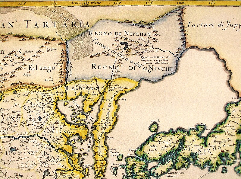
English: Northeastern fragment of a map of China (in Italian), showing the "Tartari del Kin o dell'Oro" (i.e., the Jin Tartars, or the Golden Tartars) populating the "Regno del Niulhan" (?) a.k.a. "Regno del Niuche" (i.e. the Kingdom of the Nüzhen, a.k.a Jurchen") who are further described as "The Tartars who have occupied, and at present are ruling, China". Further northeast, the "Tartari de Yupy" (i.e., "Fishskin Tartars" - the generic name of the Tungusic people of the Amur) are shown.
Italiano: "Il regno della China detto presentemente Catay e Mangin diuiso sopra le carte piu esatte nelle sue principali prouincie" |
| Tanggal | Originally published 1682; the copy at HKUST is a 1689 reprint. |
| Sumber |
English: An antique map from the Special Collection "China in Maps" of the Hong Kong University of Science and Technology Library, reproduced by the HKUST Library in the book "China in European Maps", Hong Kong, 2003. ISBN 962-86403-9-9.
Русский: Старинная карта из специальной коллекции Библиотеки Гонконгского научно-технического университета. Опубликована этой библиотекой в книге "China in European Maps" (Китай на европейских картах), Гонконг, 2003. ISBN 962-86403-9-9, тиражом 1000 экз. См. также каталог выставки, Special Collection "China in Maps".
. Fragment of Plate 36: "Il regno della China detto presentemente Catay e Mangin diuiso sopra le carte piu esatte nelle sue principali prouincie" |
| Pembuat | Giacomo Cantelli (1643-1695), Giovanni Giacomo de Rossi (1627-1691) |
| Versi lainnya |
Entire map:  |
Lisensi
|
Ini adalah suatu perbanyakan fotografis dari sebuah karya seni dua dimensi. Karya seni tersebut berada pada domain publik karena alasan berikut:
Posisi resmi Wikimedia Foundation adalah bahwa "faithful reproductions of two-dimensional public domain works of art are public domain, and that claims to the contrary represent an assault on the very concept of a public domain". Untuk detilnya, lihat Commons:When to use the PD-Art tag.
Oleh karena itu, perbanyakan fotografis ini juga dianggap berada pada domain publik. Mohon diperhatikan bahwa hukum lokal mungkin saja melarang atau membatasi penggunaan kembali berkas ini di wilayah hukum anda. Lihat Commons:Reuse of PD-Art photographs. | ||||
Riwayat berkas
Klik pada tanggal/waktu untuk melihat berkas ini pada saat tersebut.
| Tanggal/Waktu | Miniatur | Dimensi | Pengguna | Komentar | |
|---|---|---|---|---|---|
| terkini | 12 Agustus 2013 12.40 | | 1.600 × 1.186 (1,07 MB) | Soerfm | Crop, brightness |
| 18 Maret 2009 04.06 |  | 1.600 × 1.200 (1.024 KB) | Vmenkov | {{Information |Description={{en|1=Northeastern fragment of a 1682 map of China (in Italian), showing the "Tartari del Kin o dell'Oro" (i.e., the Jin Tartars, or the Golden Tartars) populating the "Regno del Niulhan" (?) a.k.a. "Regno del Niuche" (i.e. the |
Penggunaan berkas
Halaman berikut menggunakan berkas ini:
Penggunaan berkas global
Wiki lain berikut menggunakan berkas ini:
- Penggunaan pada bcl.wikipedia.org
- Penggunaan pada bg.wikipedia.org
- Penggunaan pada en.wikipedia.org
- Penggunaan pada es.wikipedia.org
- Penggunaan pada fr.wikipedia.org
- Penggunaan pada gl.wikipedia.org
- Penggunaan pada gu.wikipedia.org
- Penggunaan pada hy.wikipedia.org
- Penggunaan pada la.wikipedia.org
- Penggunaan pada nl.wikipedia.org
- Penggunaan pada oc.wikipedia.org
- Penggunaan pada pa.wikipedia.org
- Penggunaan pada pnb.wikipedia.org
- Penggunaan pada pt.wikipedia.org
- Penggunaan pada ro.wikipedia.org
- Penggunaan pada ru.wikipedia.org
- Penggunaan pada uk.wikipedia.org
- Penggunaan pada vi.wikipedia.org
- Penggunaan pada war.wikipedia.org
- Penggunaan pada zh.wikipedia.org